Open access to the datasets featured in VVG. You can use it however you like to build apps and tools, for research or to gain insights and understanding.
Popular datasets
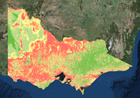
Depth To Watertable (Victoria)
Subtracts the water table surface from the land surface and presents it as a graphical display.


.png) Browse all VVG datasets via our CKAN catalogue.
Browse all VVG datasets via our CKAN catalogue.