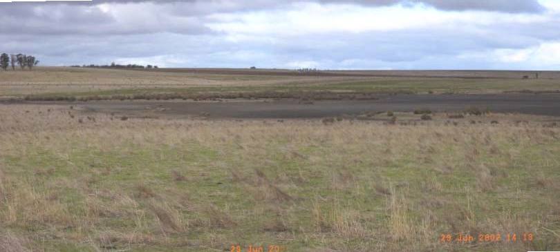
Saline area, corner Malim Road and Delacombe Way, Willaura.
Region: Majority of central and eastern GHCMA
Type areas: Hamilton South, Mininera, Woolsthorpe
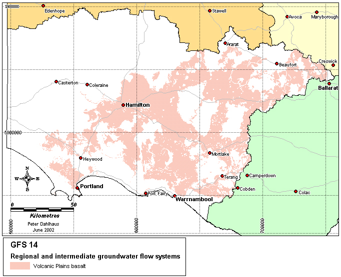
Description: The basalt rocks that make up the majority of the volcanic plains were formed by volcanic eruptions between 4 million and 7 thousand years ago. In the earlier phase eruptions, lava flowed over the pre-existing landscape, following drainage lines and spilling out across the coastal plains. The individual lava flows cooled to form lobes or tongues of basalt, generally less than 5 metres thick. Over the lengthy period of volcanic eruptions the overlapping lobes of basalt have built up to form the extensive basalt plains cover. In places, soils that had developed on the basalt were buried by the subsequent lava flows often several hundreds of thousand years later, now forming discontinuous confining layers in the basalt aquifer. The uppermost fractured, fine-grained crystalline rocks have rapidly weathered, forming a blanket of clay soil of variable thickness.
Groundwater moves through the fractured rocks at highly variable rates in both regional and intermediate flow systems. Saline groundwater discharges in lakes, streams, swamps, and over broad depressions in the landscape.
Problem statement: Salinity and shallow watertables are features of this landscape. It is unclear how much hydrologic change there has been due to land-use change. It is generally acknowledged that the pre-agricultural basalt plains were inherently 'wet' landscapes given the existence of many shallow lakes and wetlands, the climate and the grasslands (possibly shrubland) and/or open woodland. Primary salinity may have been a widespread feature, as ‘salt’ was a descriptive adjective for many of the lakes and creeks in early historical records. However, given the lack of documented hydrological change and impact across the plains, an understanding of the connection between European settlement and salinisation is yet to be explored.
Geology: Newer Volcanics basalt (Qvn) of Neogene and Quaternary age.
Topography: Volcanic plains and gently undulating plains, dissected plains, low rises.
Land Systems:
6.0 Western Plains
6.1 Volcanic plains
6.1 3 Plains with poorly developed drainage
6.1.4 Plains with well developed drainage
Regolith: Heavy clay soil and weathered rock of variable thickness.
Annual rainfall: 600 mm to 700 mm.
Dominant mid-1800s vegetation type: Grassland and open woodland (dominant); shrubby understorey in parts; forest (along the southern fringe).
Current dominant land uses: Cropping, grazing, horticulture, farm forestry, urban, conservation.
Mapping method: Outcrop geology and Land Systems
Aquifer type (porosity): Fractured rock (secondary porosity), soil (primary porosity).
Aquifer type (conditions): Unconfined and semi confined.
Hydraulic Conductivity (lateral permeability): Extremely variable. The rock varies from 10-3 m/d (tight fractures) to 102 m/d (open fracture and lava tubes); soil varies from 10-6 m/d (heavy clay) to 10-2 m/d (clayey loams).
Aquifer Transmissivity: Highly variable in the moderate to high range. Estimated to be generally less 50 m2/d to 200 m2/d.
Aquifer Storativity: Variable. Estimated to be <0.03 to >0.05 for the fractured rock.
Hydraulic gradient: Estimated to be very low (0.0001) in regional systems and low (0.001) in intermediate systems.
Flow length: Generally <50 km for regional systems and <10 km for intermediate systems.
Catchment size: Very large (>500000 Ha) for regional systems and large (>50000 Ha) for intermediate systems.
Recharge estimate: Variable with position in landscape and moisture condition of clay soils. Generally between 10 mm and 40 mm annually.
Temporal distribution of recharge: Seasonal (winter and spring), with significantly more recharge in wetter years, when extensive soil waterlogging can occur. Summer storms can provide rapid recharge where the surface soils are deeply cracked.
Spatial distribution of recharge: Catchment wide but varies with the soil thickness, slope and waterlogged areas in the landscape. More recharge can occur through where overlain by stony rises (GFS 2). Higher recharge can occur under some lakes and wetlands, or seasonally waterlogged low-lying areas.
Aquifer uses: Significant use for stock and domestic purposes, some irrigation.
Groundwater salinity: ranges from 500 to 10000 (mg/l)
Salt store: Moderate to high.
Salinity occurrence: Lakes, swamps, drainage lines, broad depressions in the landscape, boundaries of basalt flows.
Soil Salinity Rating: S1 (86%) S2, S3 and waterlogging.
Salt export: Commonly baseflow, occasional wash-off from surface.
Salt impacts: Both on-site (land salinity) and off-site (stream salinity).
Soil salinity hazard: Intuitively high, based on land area
Water salinity hazard: High
Major assets at risk: Lake and stream biodiversity, engineering and urban infrastructure, conservation areas, and agricultural land.
Responsiveness to land management: Largely unknown, but thought to be slow.
Expert opinion suggests that the plains naturally operated under conditions of seasonal wetlands and soil waterlogging (and accompanying low grade salinity?), and with brackish to saline baseflow into incised stream systems. An emerging hypothesis is that surface water management may be a key to salinity processes on the basalt plains. Natural seasonal ponding of surface waters in ephemeral depressions and wetlands may aid in 'freshening' the landscape, at the same time limiting the exposure of underlying brackish watertables that would otherwise lead to localised soil salt accumulation.
However, an implication of the assumed intrinsic hydrology of the plains and the slow response times for intermediate to regional groundwater flow systems is that regionally reducing watertables is not a practical or feasible option, be it by biological or engineering means. The realistic question is how to best deal with a naturally saturated landscape underlain by a brackish to saline shallow regional groundwater system.
Perennial pasture and woody vegetation (especially within the bounds of existing agricultural systems) are unlikely to achieve a significant result in terms of salinity benefit. In some situations, surface drainage of low-lying areas may actually increase the salinity hazard. Where there are significant assets at risk it is likely that engineering intervention will be the prime consideration.
The limited ability to control recharge means that treatment of saline areas assumes particular importance, be it through revised surface water management strategies (potentially), sowing productive species that are waterlogging and salt tolerant, or rehabilitating wetlands to restore their indigenous ecologies.
| Groundwater Flow System | Options | Treatments | Ranking |
|
Regional flow systems in the Volcanic Plains (earlier phase basalt) |
Biological Management of recharge | Perennial pastures |
Low – Insufficient evidence of salinity driven by changes in the water balance affected by increased recharge post-agricultural development. |
| Crop management | |||
| Trees/woody vegetation | |||
|
Engineering intervention | Surface drainage | Low – May even exacerbate salinity issues by altering the hydrologic balance of the valley floors | |
| Groundwater pumping | Moderate – Where high value assets are to be protected | ||
|
Productive uses of saline land and water | Salt tolerant pastures | High – Salt tolerant grasses | |
| Halophytic vegetation | Low – Poor suitability to climate | ||
|
Saline aquaculture | Moderate – Technically feasible, particularly in combination with groundwater extraction for asset protection | ||
| Salt harvesting | Low – Groundwater is not saline enough | ||
| Others | See OPUS database (NDSP) |