
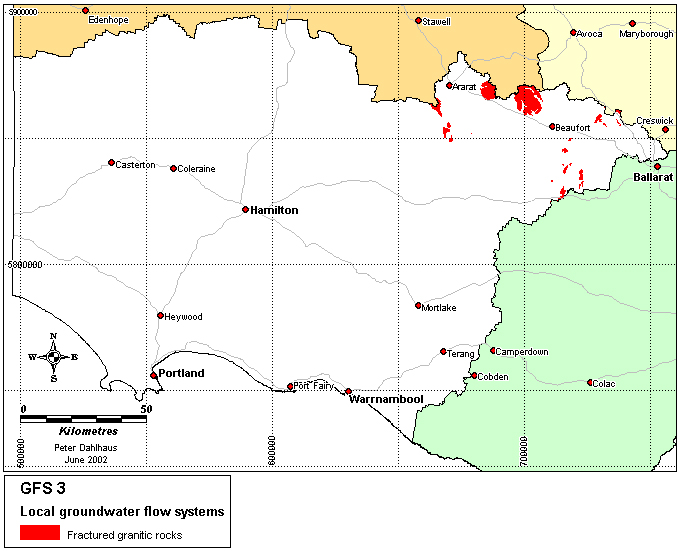
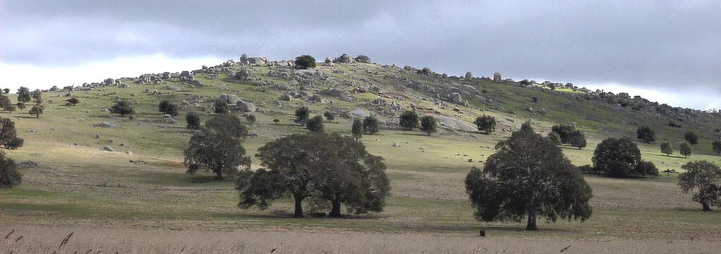
Granite tors near Burrumbeep Hill, north of Maroona.
Region: North eastern GHCMA region (Western Victorian Uplands)
Type areas: Mt Cole, Mt Langi Ghiran
Description: The granitic rocks in the north western part of the GHCMA region were formed around 350 million years ago when granitic magma cooled slowly at depths of two to five kilometres within the sedimentary rocks. The resulting crystalline rocks are now exposed by extensive erosion. In the past 15 million years, the granites have been subjected to deep weathering and sporadic erosion controlled by uplift and disrupted drainage. This has resulted in a variable regolith comprising thick kaolin clay in places, and sandy grus or granite tors elsewhere. Groundwater moves slowly through the fractured rocks and the regolith in local flow systems in a variety of pathways and processes. Discharge occurs as springs and in valley floors.
Problem statement: Land-use change has altered the water budget of the soil, regolith and fractured rock hydrologic systems.
Geology: Lower Devonian granite (Dlg), Upper Devonian granite (Dug)
Topography: Ridges and plateaus, gently undulating low hills, broad valleys, can be locally steep.
Land Systems:
2.0 Western Uplands:
2.1 Dissected Uplands.
2.1.2 Ridges and plateaux, hills and valley slopes associated with granitic rocks and aureoles
Regolith: Highly variable weathered profile (soil, grus, saprolite, tors).
Annual rainfall: 550 to 750 mm
Dominant mid-1800s vegetation type: Woodland and forest.
Current dominant land uses: Grazing, conservation, forestry, quarrying.
Mapping method: Outcrop geology, land systems.
Aquifer type (porosity): Fractured rock and saprolite (secondary porosity), soil and grus (primary porosity)
Aquifer type (conditions): Unconfined and semi confined
Hydraulic Conductivity (lateral permeability): Highly variable. The saprolite varies from approximately 10-6 m/d to 10-1 m/d, grus varies from 10-3 m/d to 10-1 m/d, and the rock varies from 10-10 m/d to 10-2 m/d
Aquifer Transmissivity: Highly variable in the low to moderate range. Estimated to be generally less than 50 m2/d.
Aquifer Storativity: Variable. Estimated to be less than <0.05 for saprolite and grus and <0.01 for the fractured rock.
Hydraulic gradient: Estimated to be moderate to locally steep.
Flow length: Generally <5 km.
Catchment size: Small (~<500 Ha) to moderate (>1000 Ha).
Recharge estimate: Unknown. May be 25 mm to 200 mm annually.
Temporal distribution of recharge: Seasonal (winter and spring), with more recharge in wetter years.
Spatial distribution of recharge: Catchment wide but varies with the depth of regolith, slope and waterlogged areas in the landscape.
Aquifer uses: Minor use, mainly for stock and domestic purposes.
Groundwater salinity: Generally in the range of 3000 mg/l to 10000 mg/l
Salt store: High
Salinity occurrence: Broad valley floor, drainage lines, small springs.
Soil Salinity Rating: S2, some S3.
Salt export: Both baseflow to streams and wash-off from surface.
Salt impacts: Both on-site and off-site
Soil salinity hazard: High
Water salinity hazard: High
Major assets at risk: Rivers and streams, engineering infrastructure, conservation areas, agricultural land.
Responsiveness to land management: Largely unknown, but thought to be moderate to high for these local flow systems.
Recharge to the fractured rock aquifer would generally be very slow due to the sparse and tight fractures in the granite. Vegetation cover is intact on a large proportion of the area held as public land forests. In cleared areas biological control measures such as blocks or belts of trees will potentially reduce recharge to the groundwater system proper, but can be more effective in reducing lateral flow through the upper regolith which will reduce the discharge 'load' accumulating on the flats. By removing this 'fresh' component, the area affected by saline discharge can be reduced in size. However, moderate to high rainfall limits the effectiveness of perennial pasture in recharge control, and soil fertility and acidity issues restrict the use of lucerne. This may leave a role for native grasses, although the recharge benefit has yet to be quantified.
Groundwater pumping is unviable due to the low permeability, deeply weathered landscape. Waterlogging control on the slopes may be assisted by surface and sub-surface drainage, but the economics and the downstream impact are problematic.
Despite the localised nature of many of the flow cells, a significant treatment strategy will revolve around treatment of the broad valley flats using salt tolerant grasses and/or indigenous vegetation to increase productivity and biodiversity.
| Groundwater Flow System | Options | Treatments | Comments |
|
Local flow systems in fractured granitic rocks |
Biological Management of recharge | Perennial pastures | Low to moderate – suitable in local systems below 700mm annual rainfall. |
| Crop management | N/a | ||
|
Trees/woody vegetation | Low to moderate – Maintain native vegetation cover and establishment of tree blocks or belts in cleared areas may intercept shallow water flows. Marginal for recharge control. | ||
|
Engineering intervention |
Surface drainage | Moderate to high – Reduction of surface waterlogging and consequent salinity impacts in local flow systems. | |
| Groundwater pumping | Low – low permeability landscapes | ||
|
Productive uses of saline land and water | Salt tolerant pastures | Moderate to high – Salt and water logging tolerant grasses | |
| Halophytic vegetation | Low – Poorly suited to climate | ||
| Saline aquaculture | Low – Poor aquifer capacity and difficult to extract groundwater | ||
| Salt harvesting | Low – Groundwater insufficiently saline | ||
| Others | See OPUS database (NDSP) |