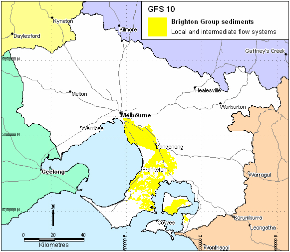
Region: South central and south east PPWP CMA region
Type areas: Brighton, Dandenong, Tyabb, South eastern French Island
Brief description: The Brighton Group sediments (including the Baxter Formation in Westernport) form part of an extensive sand sheet that was deposited by a retreating sea during the Pliocene. The relatively thin veneer of gravels, sands, silts and clays layer is exposed in the south eastern Melbourne suburbs, the Mornington Peninsula and French Island. The Brighton Group also occurs beneath the basalts plain to the west of Melbourne with limited outcrop. Some overlying Quaternary age dune sands are grouped with this GFS on the basis that they are hydraulically connected and have similar hydrogeological characteristics.
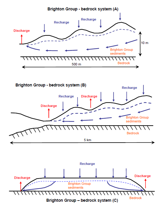
The local flow systems occur where the sand forms isolated caps on dissected ridges, especially on the Mornington Peninsula. Intermediate flow systems may develop where the Brighton Group occurs as more extensive sheet-like deposits, such in the southeastern suburbs of Melbourne and parts of the Westernport Basin. Where the unit has been extensively ferruginised or silicified, the groundwater flow pattern can be locally distorted, resulting in shorter flow paths.
Problem statement: Salinity is associated with this GFS on the Mornington Peninsula, French Island and in the Corinella area. Primary salinity was probably a feature of these systems in some places. Land-use change has resulted in increased recharge and discharge through the local flow systems, resulting in an increase in salinity. Several conceptual models for salinity processes are possible, depending on the local geology.
Geology: Baxter Sandstone (Tpx) and Brighton Group (Tpb) sediments of Neogene age, Quaternary calcareous aeolian deposits (Qpd), aeolian dunes, dune sand and minor swamp deposits (Qrd), Quaternary alluvium (Qra), lagoon and swamp deposits (Qrm).
Topography: Undulating plains and local low ridges; dissected coastal plain; palaeo-strand lines.
Land Systems:
South Victorian Uplands
3.3 Moderate Ridge – Mornington Peninsula
South Victorian Coastal Plains
8.3 Sands and Clay Plains - Moorabbin
8.4 Fans and Terraces – Westernport
8.5 Barrier Complexes – Discovery Bay, Gippsland Lakes
Regolith: Unconsolidated sand, silt and clay; ferruginous sand; calcareous sand; siliceous sand; ferruginous sandstone; occasional silcrete; minor gravels.
Annual rainfall: 650 mm to 950 mm
Dominant mid-1800s vegetation type: Predominantly Woodland but also areas of Scrub, Grassland, Forest and Rushland
Current dominant land uses: Urban and industrial development, grazing, horticulture, and conservation areas.
Mapping method: Outcrop geology
.jpg)
Salinity (S2, S3) on the Baxter – Tooradin Road, Pearcedale.
.jpg)
Salinity (S2, S3) at Gomms Rd, Somerville
Aquifer type (porosity): Gravels to fine sands, silts and clays (primary porosity), ferruginised or silicified rock (secondary porosity).
Aquifer type (conditions): Unconfined to semi-confined
Hydraulic Conductivity (lateral permeability): Variable and largely unknown. Probably from 10-2 m/d to 10 m/d, with clayey facies less than 1 m/d and sandy facies 5-10 m/d.
Aquifer Transmissivity: Variable, but generally in the moderate range. Estimated to be generally less than 20 m2/d.
Aquifer Storativity: Variable. Estimated to be from 0.05 to 0.10.
Hydraulic gradient: Estimated to be low (0.001) in intermediate systems to moderate or steep (0.01) in local systems. Could be locally steep at the edges of the Pliocene sand caps on dissected ridges.
Flow length: Unknown. Possibly up to 25km in intermediate systems to a few metres in local systems.
Catchment size: Estimated to vary from very small (<1 Ha) in local systems to moderate (>1000 Ha) in intermediate systems.
Recharge estimate: Highly variable depending on location and aquifer position. Recharge has been reduced by urbanisation in the southeastern suburbs.
Temporal distribution of recharge: Seasonal (winter and spring) where exposed at the surface, with significantly more recharge in wetter years. May be continual steady recharge where overlain by volcanics.
Spatial distribution of recharge: Catchment wide on outcrops and extensive leakage from overlying basalt (GFS 18) on the plains.
Aquifer uses: Minor stock and domestic use.
Groundwater salinity (TDS): Generally in the range of 500 mg/L to 7000 mg/L.
Salt store: Moderate to high.
Salinity occurrence: Drainage depressions (including lakes, swamps), low-lying areas, and at the boundary of the GFS.
Soil Salinity Rating: S2 to S3.
Salt export: Wash off from surface and base flow discharge to lakes and rivers.
Salt impacts: Both on-site and off-site
Soil salinity hazard: Moderate to high (scalding).
Water salinity hazard: Moderate.
Assets at risk: Engineering and urban infrastructure, conservation areas, agricultural land.
Responsiveness to land management: Largely unknown, but thought to be high for local systems and low for intermediate systems.
In places, salinity is a substantial issue within the Brighton Group sediments. Given the issue of intense urban encroachment and pressure for intensive agriculture, sitting on a landscape exhibiting locally high recharge rates (resulting in possible primary discharge pre-clearing), heterogeneous groundwater flow paths (cementing of sediments) and underlying bedrock influences on discharge, salinity management presents a significant challenge. In these circumstances it is unlikely that salinity can be significantly reduced, so that planning and engineering solutions will likely be required to avoid degradation of assets.
| Options | Treatments | Comments |
|
Biological Management of recharge |
Perennial pastures | Low impact– role of pastures in recharge control marginal, but productive pastures bring some run-off and waterlogging control benefits. Expanding urbanisation encroaching on grazed areas. |
| Crop management | Low impact– cropping is generally absent in these landscapes | |
| Trees/woody vegetation | Low to moderate impact– inhibited by expanding urbanisation, but should be optimised in open spaces | |
|
Engineering intervention | Surface drainage | Low impact– disposal issues |
|
Groundwater pumping | Low to moderate impact– disposal issues. Consider in areas where specific asset protection is required. Some higher yielding, pumpable aquifers expected. | |
|
Productive uses of saline land and water | Salt tolerant pastures | Moderate to high impact– to stabilise and aesthetically improve salt affected areas |
| Halophytic vegetation | Low impact– climate and environs not conducive | |
| Saline aquaculture | Low to moderate impact– discharge sites only minor in extent | |
| Salt harvesting | Low impact– groundwater is not sufficiently saline | |
| Others | See OPUS database (NDSP) |
Management implications given projected land use
On the Mornington Peninsula there are projected increases in urbanisation and intensive horticultural industries (e.g. vineyards) that will have significant implications for landscape hydrology. Under these circumstances, and given the nature of the salinity processes in the GFS, planning may preclude such developments in hazardous areas, and institute specific engineering standards for infrastructure to limit degradation potential.
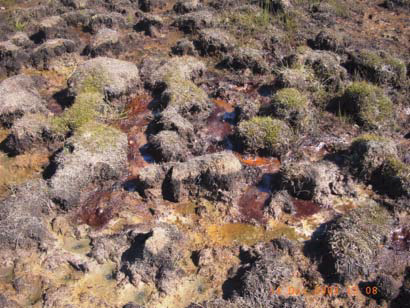
Saline discharge and iron precipitation, Bungower Rd, Moorooduc