
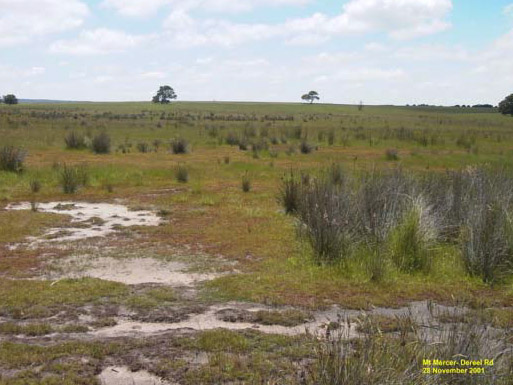
S2 and S3 soil salinity on the Mt Mercer – Dereel Road, Mt Mercer.
Region: Northern CCMA region uplands (Western Victorian Uplands)
Type areas: Cape Clear, Dereel, Linton, Mt Helen
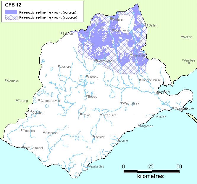
Description: The sedimentary rocks in the northern part of the CCMA region were formed around 500 million years ago during the Palaeozoic era. Since their formation they have been folded and faulted, injected with quartz veins and intruded by granites. Extensive erosion has removed several kilometres thickness of material and the exposed rocks are deeply weathered. They are covered by an uneven thickness of weathered rock and soil.
Groundwater slowly moves through the fractured rocks and regolith in both local and intermediate flow systems. On the basis of response in similar GFS elsewhere in south east Australia, this GFS should respond well to salinity management options.
Geology: Shale, sandstone, mudstone, slate and quartz veins. Cambrian and Ordovician age turbidite sediments of the St Arnaud Group (Es) and Castlemaine Supergroup (Ol, Oll, Olm).
Topography: Undulating hills, broad valleys, can be locally steep.
Land Systems:
2.0 Western Uplands
2.1 Dissected uplands.
2.1.1 Ridges, plateaux, hills and valley slopes underlain by Palaeozoic sedimentary and metamorphic rock (including greenstone).
Regolith: Variable deeply weathered profile (soil, saprolite, saprock to fresh rock).
Annual rainfall: 600 to 800 mm.
Dominant mid-1800s vegetation type: Forest.
Current dominant land uses: Grazing, forestry, urban (Ballarat), conservation.
Mapping method: Outcrop geology and estimated sub-crop
Aquifer type (porosity): Fractured rock and saprolite (secondary porosity).
Aquifer type (conditions): Unconfined and semi confined.
Hydraulic Conductivity (lateral permeability): Highly variable. The saprolite varies from approximately 10-5 m/d to 10-1 m/d and the rock varies from 10-5 m/d (measured at Ballarat) to 1 m/d.
Aquifer Transmissivity: Highly variable in the low to moderate range. Estimated to be generally less than 50 m2/d.
Aquifer Storativity: Variable. Estimated to be less than 0.03 for saprolite and 0.02 to 0.05 for the fractured rock.
Hydraulic gradient: Estimated to be moderate in intermediate systems and locally steep in local systems.
Flow length: Generally <25 km for intermediate systems and <5 km for local systems.
Catchment size: Small (~<500 Ha) for local systems and moderate (>100 km2) for intermediate systems.
Recharge estimate: Approximately 40 mm to 50 mm annually.
Temporal distribution of recharge: Seasonal (winter and spring), with more recharge in wetter years.
Spatial distribution of recharge: Catchment wide but varies with the depth of regolith, slope and wet areas in the landscape.
Aquifer uses: Minor use, mainly for stock and domestic purposes.
Groundwater salinity: Generally in the range of 1000 mg/l to 8000 mg/l.
Salt store: Moderate to high.
Salinity occurrence: Valley floor, break-of-slope, hillside seeps.
Soil Salinity Rating: S2 to S3.
Salt export: Both baseflow to streams and wash-off from surface.
Salt impacts: Both on-site and off-site.
Soil salinity hazard: High.
Water salinity hazard: Very high.
Major assets at risk: Barwon River, Leigh River, Moorabool River, Woady Yaloak Creek, Ramsar Wetlands, urban water supplies (Geelong and Ballarat), engineering and urban infrastructure, conservation areas, agricultural land.
Responsiveness to land management: Largely unknown, but thought to be moderate for intermediate flow systems and high for local flow systems.
The varied land-use, ranging from grazing, farm forestry, mining and quarrying, conservation to urban development (around Ballarat) is a significant challenge for salinity management within this GFS. These represent a spectrum of asset managers with different concerns and priorities. Apart from the obvious impacts of land salinisation, water quality is arguably the most vital asset to be protected, both from the perspective of river health as well as urban water supply (i.e. drainage from the sedimentary hills feeds the water supply reservoirs for Ballarat and the Barwon River system).
Optimal salinity management outcomes can be expected with localised groundwater flow cells in areas where the regolith is thin. With regards to recharge control, the effectiveness of perennial pastures is doubtful owing to high rainfall. Trees are viable if they are able to fit into the farming system; as happens with the expanding farm forestry industry in the Mt. Mercer - Dereel area. Engineering solutions such as groundwater pumping are not suitable for broad-scale application owing to the heterogeneity of fractured rock systems, but may be worth investigating if there is a discrete localised asset at risk. Engineering options within this GFS, however, are unlikely to be viable for sustaining the health of a river system such as the Barwon.
| Groundwater Flow System | Options | Treatments | Comments |
|
Intermediate and local groundwater flow systems in Palaeozoic sedimentary rocks |
Biological Management of recharge | Perennial pastures | Low to moderate – Limited by high rainfall and responsiveness give n scale of groundwater flow |
| Crop management | N/a | ||
|
Trees/woody vegetation | High for local systems - Planting over fractured rock outcrops in responsive aquifers Low to Moderate for intermediate systems – limited salinity benefit in the longer term. | ||
|
Engineering intervention | Surface drainage | Low – Very limited opportunity to intercept surface water to prevent recharge | |
| Groundwater pumping | Moderate – Where high value assets demand protection | ||
|
Productive uses of saline land and water | Salt tolerant pastures | Moderate to high – Salt tolerant grasses with existing technologies | |
| Halophytic vegetation | Low - Unsuitable climate | ||
| Saline aquaculture | Moderate – Technically feasible, providing salt and nutrients can be managed. | ||
| Salt harvesting | Low – Groundwater not saline enough | ||
| Others | See OPUS database (NDSP) |