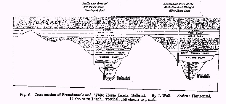
Cross-section through two Deep Leads at Ballarat, showing the river valleys buried by the lava flows (basalt rock) from volcanic eruptions about 2 million years ago. Groundwater flows along the gravels of the ancient river beds.
Diagram from: BARAGWANATH, W. 1923. The Ballarat Gold-field. Memoir 14. Geological Survey of Victoria. p. 16.
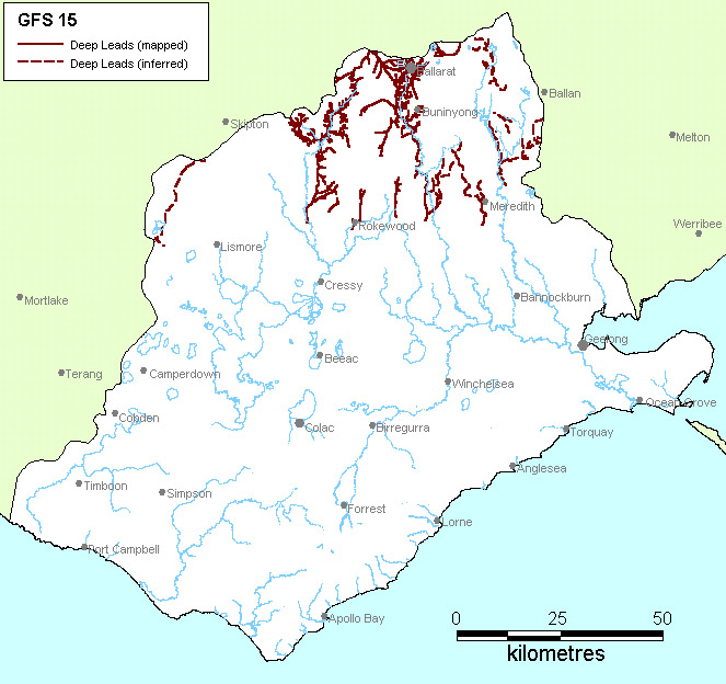
Region: Northern CCMA (Western Uplands)
Type areas: Woady Yaloak, Pitfield Plains
Description: Deep Leads are ancient river valleys buried by volcanic lava flows or the build up of sediments (or both). They include the ancient Yarowee, Moorabool and Woady Yaloak, rivers and their tributaries. They were a valuable source of gold in the early mining history of the region and most have been extensively mined.
High volumes of groundwater flow south along the buried river alluvium (gravel, sand, silt and clay) except around Ballarat, where some of the ancient rivers flowed north into the Murray Basin. Control of the water flow through the buried river deposits was a considerable problem for the early gold miners. The influence of these regional groundwater flow systems on salinity in the CCMA region is unknown, as little is understood about the hydraulics of deep lead pressures and how these pressures are dispersed beneath the basalt plains south of Rokewood and/or north of Ballarat. There is, however, a hypothesis that some salinity outbreaks mapped at the hills - plains interface may be a function of reducing hydraulic gradients in these systems.
As the deep lead systems are high flow regional groundwater systems, groundwater salinity and salt store is generally only expected to be moderate. The key salinity impact is likely to be caused by elevated baseflow occurring in interbasaltic streams. However, the exact impact of these systems on the salinisation of land and water resources is best described as uncertain.
Geology: Deep Leads (Calivil Formation equivalent).
Topography: Subsurface buried river valleys.
Land Systems:
Subsurface in 2.0 Western Uplands
2.1 Dissected Uplands
Subsurface in 6.0 Western Uplands
6.1 Volcanic plains
Regolith: Not applicable.
Annual rainfall: 600 to 750 mm at recharge areas.
Dominant mid-1800s vegetation type: Not applicable.
Current dominant land uses: Resource used as water supply.
Mapping method: Estimated subsurface distribution.
Aquifer type (porosity): Gravel, sand, silt and clay (primary porosity)
Aquifer type (conditions): Confined, may outcrop at headwaters.
Hydraulic Conductivity (lateral permeability): Largely unknown. Estimated range from 10-2 m/d to 102 m/d.
Aquifer Transmissivity: Generally less than 1000 m2/d.
Aquifer Storativity: Estimated range from 0.05 to 0.2.
Hydraulic gradient: Generally low to very low.
Flow length: Estimated up to 30 km.
Catchment size: Estimated to be <20000 Ha.
Recharge estimate: Unknown.
Temporal distribution of recharge: Unknown. Probably marginally seasonal (winter and spring), with more recharge in wetter years, but may be relatively even leakage through overlying basalt and sediment throughout the year.
Spatial distribution of recharge: General leakage from overlying Newer Volcanics (GFS 13, GFS 2) and Quaternary sediments (GFS 1).
Aquifer uses: Irrigation, stock and domestic use.
Groundwater salinity: Unknown. Probably in the range of 200 mg/l to 3000 mg/l.
Salt store: Low.
Salinity occurrence: Unconfirmed discharge on basalt plains (GFS 14).
Soil Salinity Rating: Unknown.
Salt export: Unknown. Possible baseflow to streams.
Salt impacts: Unknown. Possible off-site (baseflow and surface salinity).
Soil salinity hazard: Unknown. Potentially a risk to Basalt Plains salinity.
Water salinity hazard: Unknown. Potentially a risk to Basalt Plains salinity.
Major assets at risk: Unknown (if any)
Responsiveness to land management: Unknown
As these systems are usually recharged from overlying flow systems the ability to control recharge is substantially reduced. However, given the system permeability and throughflow, groundwater pumping presents a significant opportunity for both alleviating groundwater pressures and providing supply opportunities. As the link between deep leads and surface salinisation is tenuous there is little reason to comment on saline agronomy opportunities.
| Groundwater Flow System | Options | Treatments | Comments |
|
Regional flow systems in the subsurface Deep Leads |
Biological Management of recharge | Perennial pastures | Low – Scale of system is too large to be responsive |
| Crop management | As above | ||
| Trees/woody vegetation | As above | ||
|
Engineering intervention | Surface drainage | As above | |
|
Groundwater pumping | Moderate to high – If required to protect major assets, or where groundwater can be extracted as a resource | ||
|
Productive uses of saline land and water | Salt tolerant pastures | Moderate to high – Salt tolerant grasses (if and when salinity is identified as an issue) | |
| Halophytic vegetation | Low – Poorly suited to climate | ||
|
Saline aquaculture | Moderate to high – Potential for saline & non saline aquaculture providing salinity and nutrients can be managed | ||
| Salt harvesting | Low – Salinity of groundwater too low | ||
| Others | See OPUS database (NDSP) |